
An Rath [Eagle Hill]
Good walks are even better shared.
Overview
An Rath [Eagle Hill]
Overview
An Rath, standing at 292 meters, might not break any height records, but what it lacks in stature, it makes up for in character. Nestled in the heart of the magnificent Mourne Mountains of Northern Ireland, this Marilyn offers a splendid hiking experience for enthusiasts of all levels.
Geology
The hill is predominantly granite, interspersed with schist outcrops, which tells a tale of the area's volcanic origins. These geological features not only add to the beauty of the region but also provide a glimpse into the ancient natural forces that shaped the landscape.
Routes
There are several routes available for tackling An Rath. The Mourne Wall Route is particularly popular, guiding hikers along the famed wall that offers both a challenging trek and incredible vistas. Alternatively, the Forest Path Route serves as a gentler introduction, suitable for families who wish to enjoy nature at a more leisurely pace.
Summit Features
Reaching the top rewards your efforts with a well-constructed cairn, perfect for resting or taking some awe-inspiring photos. Just be sure to keep your footing; while the summit is rewarding, it can be surprisingly tricky to navigate after a full day of exertion!
Terrain Type
The terrain varies from rocky outcrops to grassy slopes. That's right, bring your sturdy boots — flip-flops are not advised unless you’re aiming for an amusing Instagram fail.
Views
Once you make your way to the summit, the views are nothing short of breathtaking. You can see the surrounding Mourne Mountains, the Irish Sea, and even the distant continuous peaks of Dublin’s Wicklow Mountains emerge on the horizon. Spring and summer are ideal for viewing, though the kaleidoscope of autumn colours cannot be underestimated!
Hazards
Be wary of the rapidly changing weather conditions, typical of mountainous areas. Slippery rocks and boggy patches also pose potential hazards, so keep your wits about you!
Nearby Summits
If you're feeling ambitious, nearby peaks like Slieve Donard and Slieve Commedagh are waiting to be conquered, providing further excitement for the seasoned hiker.
Access
Access is straightforward with a parking area located conveniently at the base of the Mourne Wall. Newcastle, the closest town, is well-equipped with amenities and public transport, albeit a bit scattered.
Facilities
Grab a well-deserved bite in Newcastle before or after your trek. Cafes, public toilets, and local delicacies await — just remember to stay hydrated!
History
The name An Rath reflects its historical significance, with ancient settlements believed to have once flourished in this picturesque area. The rich folklore speaks of giants and remarkable stories from a time long past, adding a layer of enchantment to the already breathtaking scenery.
Explore routes near An Rath [Eagle Hill]
Public walks starting within 80 km of this hill. Nearby does not mean a route reaches the summit; check its map and access before setting out.
No public routes are currently listed within 80 km of An Rath [Eagle Hill] on Walkmates. This does not mean there are no paths here. Explore the map and check local access information before planning a walk.
Route planning notes
These notes describe possible approaches, not verified navigable routes or permission to cross land. Check current paths, local access rules and conditions before setting out.
Mourne Wall Route
A scenic route that follows the Mourne Wall, taking you up towards the summit of An Rath with panoramic views over the rugged terrain.
Forest Path Route
An easier approach that starts through lush forest paths leading to more open terrain as you approach the summit. Suitable for families.
Make a day of it, together
Find someone to share the walk with, or organise a day out along a route you like.
Hill facts and local notes
Classifications
Elevation
155m
509 ft
Prominence
118m
Coordinates
51.7514, -10.1149
V540575
OS Map
84
At the Summit
The summit features a prominent summit cairn, providing a perfect spot for a well-deserved rest — just don't trip over your own enthusiasm on the way up!
Terrain & Geology
An Rath is primarily composed of granite with areas of schist, which give it a rugged appearance. The geological history provides insights into the ancient volcanic activity that shaped this dramatic landscape.
Views & Scenery
On clear days, you can see the stunning Mourne Mountains, the Irish Sea, and the distant outline of the Dublin and Wicklow mountains.
History & Heritage
Name Origin
An Rath translates to 'The Fort' in Irish, reflecting the hill's historical significance as a location of ancient settlements.
Historical Significance
The Mourne Mountains, including An Rath, have been an area of myth and folklore for centuries, often tied to local tales of giants and ancient tribes.
Getting There & Facilities
Check current local access restrictions, parking rules and transport timetables before travelling. These notes do not confirm public access to the summit.
Parking
There is a car park at the base of the Mourne Wall, accessible via the A2 road, offering ample space for vehicles.
Public Transport
While public transport options are limited, you'll find occasional buses from Newcastle to nearby stops. Taxi services are available for a more direct approach.
Nearby Facilities
In Newcastle, you can find a range of cafes, restaurants, and public toilets. If you've worked up an appetite, try the local fish and chips — a true Northern Irish treat!
Safety Information
Known Hazards
- Watch out for unpredictable weather; conditions can change rapidly in the mountains. Additionally, the rocky terrain can be slippery, especially in wet weather.
General Safety Tips
- Check weather conditions before setting out
- Carry appropriate clothing and equipment
- Let someone know your planned route
- Take a map, compass, and GPS device
- Carry emergency supplies: food, water, first aid kit, torch
Hills
Some common questions about the hills answered
Are there group walks up An Rath [Eagle Hill]?
Many walkers use Walkmates to join or organise walks with others. You can check for group walks around An Rath [Eagle Hill] through the maps
Are there other walkers around An Rath [Eagle Hill]?
Activity varies by location and time, but Walkmates lets you see whether others have shared walks or shown interest in this area. Find other people through the walking friends search walking friends for An Rath [Eagle Hill] search or of course create your own walk for An Rath [Eagle Hill]
Can I organise a walk to An Rath [Eagle Hill]?
Yes. If there aren’t any walks listed already, you can create a walk and make it available for others to join.
If you're signed up to Walkmates, you can create a walk to An Rath [Eagle Hill].
How do I find a walk up this hill?
There are often multiple ways to walk this hill, depending on experience and route preference. Walkmates helps you explore walks and routes that others have shared.
Can I suggest a new route up An Rath [Eagle Hill]?
Yes. You can suggest or create routes to share with others. Walkmates focuses on the social side of walking, so routes are used to help people organise walks and explore areas together, rather than as detailed navigation tools or route libraries.
Other uses really appreciate knowledgeable walkers sharing their routes. Share your favourite route to An Rath [Eagle Hill] here
The is an error or something incorrect about this hill. How do I let you know?
We always strive to keep the information on Walkmates as accurate as possible. If you find an error, please let us know through the contact form and we'll aim to correct it as quickly as possible
Community Discussion
Comments
Location
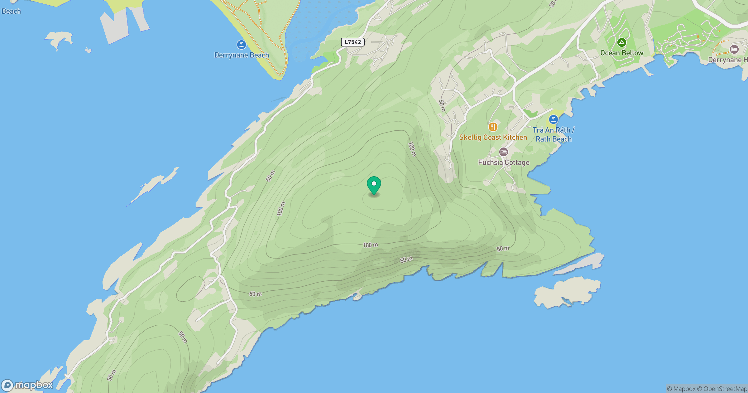
Grid reference: V540575
View on OpenStreetMapOpens a map in a new tab, centred on the hill.
Hills within 30 km
Straight-line distance, not a walking route or confirmation of access.
Sceilg Mhichil [Great Skellig]
217m
Sliabh Chathair na Gaoithe [Cahernageeha Mountain]
499m
Binn Ui Ruairc [Beenarourke]
304m
Eagles Hill [An Bhinn Riabhach]
549m
Eagle Hill
223m
No comments yet. Be the first.